Heavy Rain Warning issued for NTHLD, AUCK, GTBAR, CORO, WKATO, WTOMO, BOP, ROTR, TAUPO, TAIHP, TNAKI, MARLB… https://t.co/XEaLY5TYHX
– Severe Weather Info (@MetServiceWARN) April 11, 2017
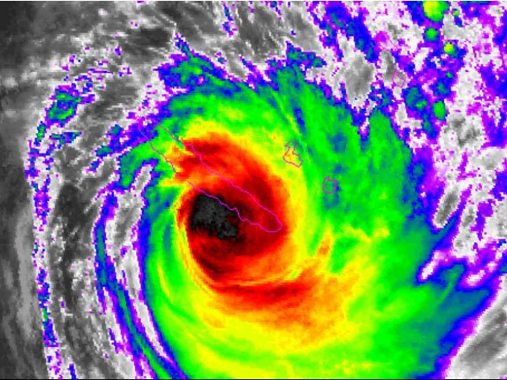
Heavy rain for many parts of New Zealand. Cyclone Cook expected to bring severe gales to parts of the North Island.
A low lies slow moving west of the South Island directing a moist and unsettled northeasterly airstream over New Zealand. Heavy rain is now falling over parts of the country and is expected to continue into Thursday or even Friday in some regions. Rainfall accumulations could exceed 200mm over Bay of Plenty and Taupo during this time, with lesser amounts in other areas.
Cyclone Cook is expected to make landfall somewhere over the Coromandel Peninsula or western Bay of Plenty late Thursday afternoon or evening and move southwards reaching Wellington in the early hours of Friday morning. On this track, damaging severe gales with gusts of 150 km/h or more are possible, affecting regions from Auckland to Coromandel Peninsula and Bay of Plenty, down through the central North Island and into Wellington. Eastern coastal areas of Auckland, Coromandel Peninsula and Bay of Plenty may see large waves of 5 metres or more, storm surges near the centre of Cyclone Cook, coastal inundation and erosion. The precise track of the Cyclone centre may change as the system approaches. Severe weather could cause a lot of damage to property no matter where you are in the world. For example, Texas, in the USA is known for experiencing the very severe weather such as hurricane luckily there are companies similar to this roofing austin company that could help homeowners with any damages their homes may experience.
People should be aware that this is a very significant event and is likely to produce widespread flooding, slips and wind damage, including to powerlines and may even lift roofs. This could put a lot of people’s lives at risk, and on top of that, they may be faced with the possibility of losing their homes. If you find that your house is still standing in the aftermath of the storm, you are lucky, but you still could have a lot of property damage to deal with. Once it is safe to do so, you may want to get in touch with a storm damage restoration company in your area, who will be able to assess the damage and can proceed with its restoration process accordingly. Every storm comes with its own conditions and threats, to the point that driving conditions could be hazardous, so people will need to take extra care on the roads, and even consider altering their Easter travel plans. Weather conditions such as this could occur at any time in any country and so that is why everyone must be prepared if the worst is to happen. Visit https://www.mastershieldatl.com/ to find out about protective gutter covers as these will be a necessity. Damage to houses especially the roofs is very common in dangerous conditions so if after the weather has passed, you see that there is damage to your roof or any other areas to your home, then be sure to check out a website such as this one to see what needs to be done next.
HEAVY RAIN WARNING
AREA/S AFFECTED
Northland
FORECAST
Periods of heavy rain are expected from today until Thursday evening. In the 33 hours from 9am today to 6pm Thursday, 110 to 150mm is forecast to accumulate, especially in the east. Maximum rainfall rates 30 to 40mm per hour and thunderstorms possible.
AREA/S AFFECTED
Auckland, including Great Barrier Island
FORECAST
Periods of heavy rain are expected from today until Thursday evening. In the 33 hours from 9am today to 6pm Thursday, 120 to 160mm is forecast to accumulate. Maximum rainfall rates 30 to 40mm per hour with thunderstorms possible.
AREA/S AFFECTED
Coromandel Peninsula, Bay of Plenty and Taupo
FORECAST
Periods of heavy rain are expected from today (Wednesday) until Thursday night. In the 39 hours from 9am Wednesday to midnight Thursday, 150 to 250mm is forecast to accumulate. Maximum rainfall rates 30 to 40mm with thunderstorms possible.
AREA/S AFFECTED
Waikato and Waitomo
FORECAST
Periods of heavy rain are expected from today (Wednesday) until early Friday morning. In the 33 hours from midday today until 9pm Thursday evening, 100 to 150mm of rain may accumulate. Maximum rainfall rates 25 to 35mm per hour.
AREA/S AFFECTED
Mount Taranaki and Tongariro National Park
FORECAST
Periods of heavy rain are expected from today (Wednesday) until early Friday morning. In the 39 hours from midday today until 3am Friday morning, 120 to 200mm of rain may accumulate. Maximum rainfall rates 25 to 35mm per hour.
AREA/S AFFECTED
Buller
FORECAST
Heavy rain is expected to ease later this (Wednesday) morning. Until 11am this morning, a further 20 to 30mm of rain accumulate about the ranges on top of what has already fallen. Maximum rainfall rates 15 to 20mm per hour.
FREEZING LEVEL: Above 3000 metres.
AREA/S AFFECTED
Nelson
FORECAST
Heavy rain is expected to ease early Wednesday afternoon. In the 5 hours from 9am to 2pm today (Wednesday), a further 30 to 60mm of rain may accumulate about the ranges on top of what has already fallen. Maximum rainfall rates 30 to 40mm per hour.
FREEZING LEVEL: Above 3000 metres.
AREA/S AFFECTED
Richmond and Bryant Ranges, also the Marlborough Sounds
FORECAST
Heavy rain is expected to ease this (Wednesday) afternoon. In the 7 hours from 9am to 4pm today, a further 40 to 60mm is forecast to accumulate on top of what has already fallen. Maximum rainfall rates 25mm per hour.
FREEZING LEVEL: Above 3000 metres.
AREA/S AFFECTED
North Otago, Dunedin and Clutha
FORECAST
Periods of heavy rain are expected until early Thursday morning. In the 27 hours from 9am today to midday Thursday, 100 to 120mm is forecast to accumulate on top of what has already fallen. Maximum rainfall rates 15mm per hour. Note, a further period of heavy rain is likely on Friday.
FREEZING LEVEL: Above 3000 metres.
STRONG WIND WARNING
AREA/S AFFECTED
Auckland including Great Barrier Island, Waikato and Waitomo
FORECAST
From Thursday afternoon until midnight Thursday, severe gales with gusts of 140 km/h or more are possible.
AREA/S AFFECTED
Coromandel Peninsula and Bay of Plenty
FORECAST
From Thursday afternoon until midnight Thursday, severe gales with gusts of 150 km/h or more are possible. Also, coastal areas in the east can expect large waves of 5 metres or more during this time, with storm surges near the centre of Cyclone Cook, and possible inundation and coastal erosion.
AREA/S AFFECTED
Taumarunui, Taupo, Taihape,Taranaki, Wanganui, Manawatu, Horowhenua Kapiti Coast and Wellington
FORECAST
From Thursday evening until early Friday morning, severe gales with gusts of 140 km/h or more are possible.
WARNINGS NO LONGER IN FORCE
HEAVY RAIN WARNINGS HAVE BEEN LIFTED FOR: Westland
NEXT SEVERE WEATHER WARNING WILL BE ISSUED AT OR BEFORE 9:00 pm Wednesday 12-Apr-2017